
Disclaimer: machine translated by DeepL which may contain errors.
The Rigakubu News
The Rigakubu News, May 2025.
Research Student Communicates to Faculty >
Finally Reached in Space! Release of Atmospheric Reanalysis Data JAWARA
Kaoru Sato, Professor, Department of Earth and Planetary Science
The vastness of space extends above the Earth's atmosphere.
Do you know at what height the boundary between space and the atmosphere is?
The Earth's atmosphere is mainly a mixture of nitrogen and oxygen molecules, with a ratio of about 4:1.
This mixture can be found down to an altitude of about 100 km. This is because it is well stirred by atmospheric motion.
On the other hand, above an altitude of about 100 km, molecules with smaller masses are in a state of gravitational separation that extends upward,
creating a different world where the mixing ratio is not constant.
This altitude of about 100 km is considered to be the boundary between space and atmosphere, or the "lower edge of the universe.
![]()
The atmosphere up to about 100 km is almost non-ionized and electrically neutral, and is also called the "neutral atmosphere. The neutral atmosphere can be divided into the troposphere (from about 10 to 17 km from the ground), stratosphere (up to about 50 km), mesosphere (up to about 90 km), and lower thermosphere (up to about 100 km) based on the temperature structure. The density of the atmosphere, on the other hand, decreases exponentially to 1/10th of that at an altitude of about 16 km, and at an altitude of 100 km it is only about 1/2 millionth of that at ground level.
Then, do phenomena in the mesosphere and lower thermosphere ( MLT*1) have no effect on the Earth's climate? The answer is yes. Conservation of angular momentum is one of the fundamental laws of atmospheric hydrodynamics, but waves of various sizes in the atmosphere have the property of redistributing angular momentum. This redistribution creates a large north-south flow, and the continuity of the atmosphere also creates up and down flow, with far-reaching effects downwards (called the "downward control principle"). In other words, a physical understanding of the entire atmosphere down to the lower edge of the universe is necessary to achieve more reliable weather forecasting over longer periods of time.
However, direct observation of the MLT region is extremely difficult because it is far from satellites and the ground, and can only be explored by satellite observations of atmospheric radiation. In addition, most climate models cover only the lower mesosphere. Therefore, the MLT region has long been regarded as a difficult area to study.
We wanted to make the MLT region a researchable area. We developed a method to obtain physically consistent wind speed, temperature, density, and pressure data (data assimilation) by utilizing limited satellite-based radiation observations in combination with an atmospheric general circulation model based on the fundamental equations of the atmosphere. As a result of nine years of research, we succeeded in producing hourly gridded data of the entire neutral atmosphere for more than 20 years from September 2004 to December 2024. This data was named JAWARA and is now available to the public.
The MLT region is dominated by small wavelength atmospheric gravity waves that are restored by the buoyancy of the atmosphere. Therefore, it is important to investigate the role of atmospheric gravity waves themselves by capturing them with models and observations in order to understand the physics of the MLT region. JAWARA has attracted international attention, and cross-disciplinary studies of tidal waves in the MLT region and their effects on the ionosphere are underway with the participation of ionospheric researchers. This is expected to greatly advance our integrated understanding of the atmosphere.
* 1: Mesosphere and Lower Thermosphere
* 2: The largest atmospheric radar in Antarctica, PANSY stands for Program of the ANtarctic SYowa MST/IS radar. PANSY stands for the Program of the ANtarctic SYowa MST/IS radar, named after the French word "pansy," which means to think about the physics of the Antarctic atmosphere by observing it with radar.
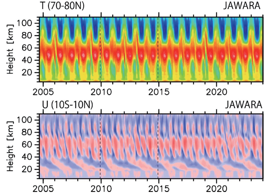 JAWARA is the world's first reanalysis data covering the entire atmosphere from the ground to an altitude of 110 km. 19-year time-height cross sections of Arctic air temperature and equatorial zonal winds (from Koshin et al . , 2025 ).
The results of this study were published in D. Koshin, et al . , Progress in Earth and Planetary Science, 12, 1 (2025).
(Press release on January 10, 2025)